A significant factor for the operation of airports is the weather conditions. In some regions, airport weather conditions change rapidly, so knowing whether there will be freezing rain or dramatic changes in the wind speed or barometric pressure can be crucial to making decisions about airplanes taking off and landing.
Therefore, airports need to rely on some kind of weather reporting system capable of providing them with accurate and reliable weather data to ensure safety in difficult weather conditions.
But, what system could make this possible? You may ask. Well, the answer is the Automated Weather Observing System (AWOS). Let’s see what this system is and what it can do.
As it was stated before, AWOS stands for Automated Weather Observing System. This means that AWOS is a system that can collect and report data about airport weather conditions automatically.
AWOS systems generally report airport weather data continuously and in real-time, and they can be configured to the specific airport needs.
AWOS systems are also known as AWOS stations, and they are generally operated by aviation service providers or government agencies such as the Federal Aviation Administration in the United States.
While AWOS are automated and very powerful systems, they are classified in different levels that represent the scope of their sensing capabilities. The different levels include A, I, II, III, and IV, with different subcategories for levels III and IV.
The most commonly used AWOS stations fall in level III, so we will focus on them.
What data do AWOS systems in the AWOS III level report?
As mentioned above, there are subcategories in level III of AWOS. Each of them represents a specific difference in the capabilities of AWOS systems that belong to this level. Let’s see each subcategory in detail:
AWOS level III
AWOS at this level includes the settings from AWOS A, AWOS I, and AWOS II with additional capabilities specific for level III. All these are:
Barometric pressure and altimeter in inches of Mercury
AWOS at this level report all weather data above plus precipitation type to identify rain, snow, drizzle, hail and ice pellets.
AWOS level III T
AWOS at level III T also reports all the weather data mentioned in level III with thunderstorm detection added to their capabilities via a cloud-to-ground and cloud-to-cloud lightning detector.
AWOS level III P/T
These AWOS take all the weather data reporting capabilities from level III and add both identifications of the type of precipitation and thunderstorm detection.
So far, you should have a good idea about AWOS. To help you understand the difference when comparing it with ATIS, we will describe what ATIS is first.
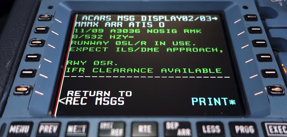
ATIS stands for Automated Terminal Information Service. It is considered the complete type of weather data report system as it includes data entered by human observers that complement the automated weather observation.
So, when comparing AWOS vs. ATIS, it is clear that the main difference is the human factor. AWOS systems do not require human observers to function but also lack the observed weather data that those observers add.
ATIS is usually used in the biggest and busier airports which are typically categorized Class B, and C. Data found in the ATIS report include:
Other information that is added as commentary by the human observers, including construction notices, runway and taxiway closures, transient conditions, birds, severe weather.
To summarize, the real benefit of having ATIS instead of AWOS is that an ATIS broadcast is the commentary section that the automated system cannot add. However, it is essential to highlight that ATIS systems are more expensive and only function in airports with towers. Therefore, ATIS reverts to the automated system when the tower is not operative. In the US, some airports have AWOS and some have ASOS. The broadcast is switched over to whichever automated system they have. Let’s talk more about ASOS.
Image source: https://ansart.nl/atis/
Automated Surface Observing System (ASOS)
An ASOS station is an automated weather station commonly used in airports around the United States. The US Government ASOS systems are old and new ones are not being installed anymore and the existing ones are maintained by the government instead of private companies. ASOS systems cannot generate weather forecasts.
AWOS and ASOS systems
Both systems can report primary data required for airports to operate correctly, including cloud ceiling and sky conditions, visibility, temperature, dew point, altimeter settings and wind speed, gusts, and direction.
ASOS systems provide a compelling set of weather data derived from readings into the US network, so airport operators can use it to make better decisions.
Another relevant aspect of the automated surface observing system in the United States is that they are usually operated and controlled by government agencies such as the National Weather Service (NWS), the Department of Defense (DOD), and sometimes the Federal Aviation Administration (FAA).
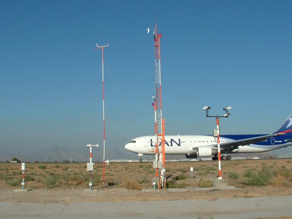
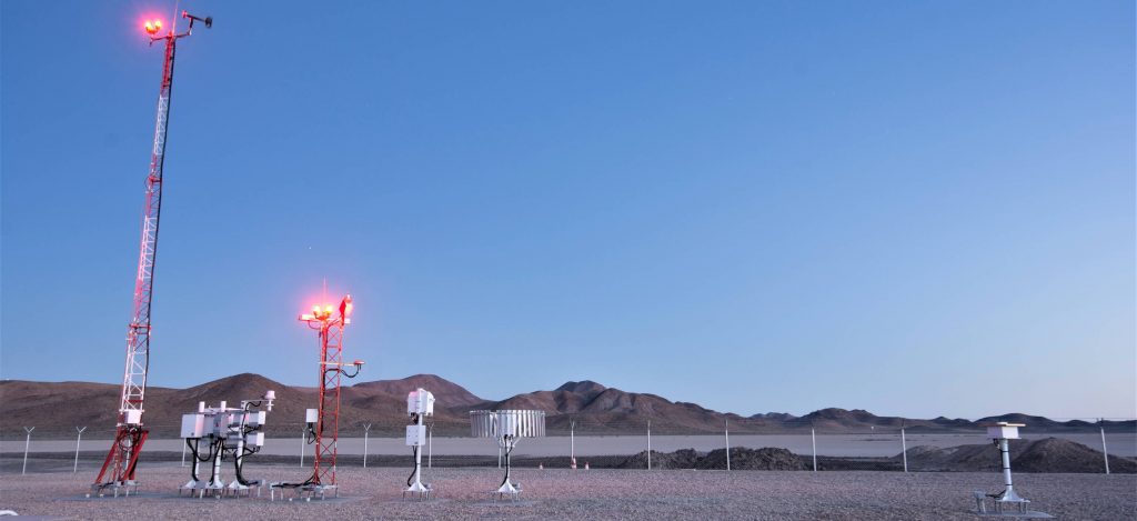
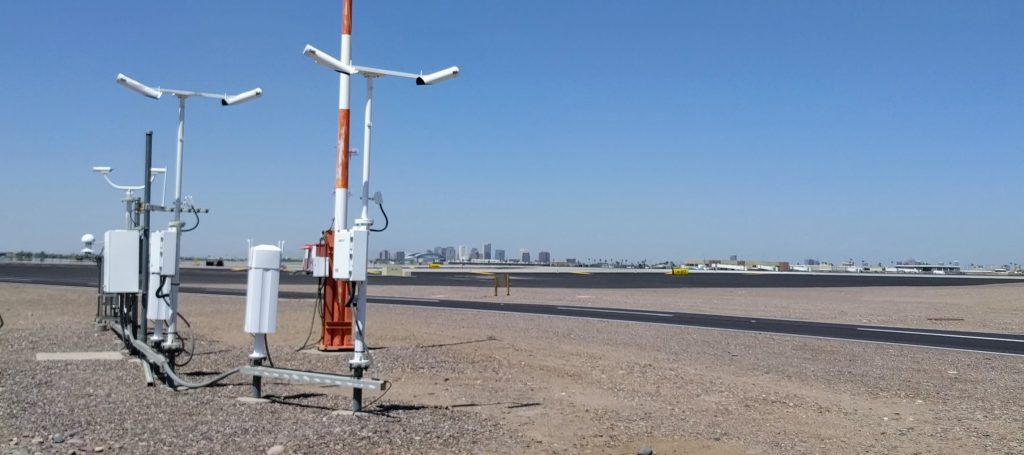
How does AWOS collect data?
As it was mentioned before, there are different types of data collected by these systems. Whether it is freezing rain, variable wind direction, variable visibility, or any other type of data, there is a specific way to collect it. Let’s see some details.
There are two standard sensors to measure wind, which are the traditional anemometer and wind vane. Mechanical wind sensors are still used in modern systems. The ultrasonic sensors have problems in certain environments, so the choice of sensor is location-specific. The latter uses high-frequency sound pulses to measure the difference in transmission time between the emitter and the receiver.
The sensors used to measure visibility are called forward scatter sensors and transmissometers. Forward scatter sensors direct an offset infrared beam toward a sensor that detects the infrared light deflected into the sensor by atmospheric particulates. The ratio of this deflection is used to calculate the visibility.
Transmissometers use a similar technique but observe the reduction in brightness of the transmitted beam over a fixed, known distance. Modern runway visual range systems use forward scatter sensors because there are lower maintenance requirements and they can read down to zero feet. New installations of transmissometers are not allowed in the US for CAT II/III approaches, only forward scatter systems and most transmissometers in the US have been replaced. However, this does vary from country to country,
When it comes to temperature and dew point, we see thermometers and hygrometers, or the combination which is known as hygrothermometer.
RTDs or resistive temperature devices are used as a standard thermometer. They are useful on aircraft to measure air temperature on the outside or temperatures of some operating components of the aircraft.
Static pressure sensors are used for barometric pressure measures. These sensors work in a similar way to the altimeter of an aircraft. They are usually applied in double or triple redundancy settings.
With barometric pressure measures, the system then calculates density altitude using the following formula:
Density Altitude = Pressure Altitude (ft) + (120 * (OAT – ISA Temperature)
Ceilometers are the ones applied for measuring cloud height. They use an infrared or ultraviolet laser pulse to determine cloud height based on signal return time. However, this laser pulse technology can fail in the case of moisture or airborne particulates.
So-called Present Weather Sensors are used to determine the type of precipitation by using an infrared LED to detect scintillation patterns from falling particulates. These systems are only able to detect rain or snow. This sensor does not detect other forms of precipitation.
Accumulation sensors are generally called “tipping bucket rain gauges” because, in essence, they are calibrated buckets. The system accumulates one hundredth (0.01) of an inch of precipitation in a carefully balanced bucket. That bucket tips when sufficient weight is present, and a computer counts the number of buckets that are filled over time. However, a freezing rain sensor is required in the case of freezing precipitation.
Weather data distribution by the weather observing system AWOS
Automated systems generally report weather data in a variety of ways. Here are some of them:
Broadcasting a computer-generated voice message via radio frequency to the pilots in the vicinity of the airport. This is the only way AWOS is forced to report weather information, and the broadcast should be updated every minute at least.
Another option is having a computer-generated voice message, available over a telephone dial-up modem service. Again, the message should be updated at least once per minute. However, this form of weather reporting is not obligatory in AWOS.
Finally, AWOS messages may be distributed via ground data link in METAR format, typically once every 30 minutes. Although this is not obligatory, it is frequently used.
How much does an AWOS system cost?
As it happens with many other technologies and systems, the price of an automated weather station is not fixed, as it varies from one offering to the other in a wide range.
Typically, the prices of the most common systems range from $20,000 to $100,000, depending on the level of weather reporting.
Also, it is essential to consider that these systems, like any other, require some maintenance, which carries an associated cost in the range of $5,000 to $7,000 per year. Additionally, in the United States the FAA provides funding for such investments.
Want to read more like this?
Enter your email and get curated content straight to your inbox!
Thank your for your subscription.
You are already subscribed to this newsletter.
Aeroclass Team
A team of professionals with a deep passion for the aviation industry bringing you the newest and the most striking industry-related news and content.
Leave a comment
Recent posts
“Remove Before Flight” Tags on Aircraft
Aircraft · 6 min read
The superficial meaning of the words "Remove Before Flight" is "remove these tags before the plane takes to the air". What it really means is to remove all the protective covers and pins that protect against third-party objects before a flight.
Jun 19, 2024
How Fast do Planes Fly
Aircraft · 4 min read
Travel by plane became the main option for reaching the places people never dreamed of seeing long decades ago. Not just because we are talking about one of the main means of transportation capable of reaching places previously inaccessible - or challenging to reach - to most people.
May 31, 2024
Surging Aircraft Leasing Market Fuels High Demand for Expert Talents
Aircraft · 1 min read
The global aircraft leasing market, which has been on a steady rise for a number of years, is expected to surge to even greater heights in the coming decade. By 2029 the aircraft leasing market is estimated to reach the value of almost 300 billion USD.